
Hiking on the Orvieto Cliff Ring
Introducing the Tour: The Cliff Ring
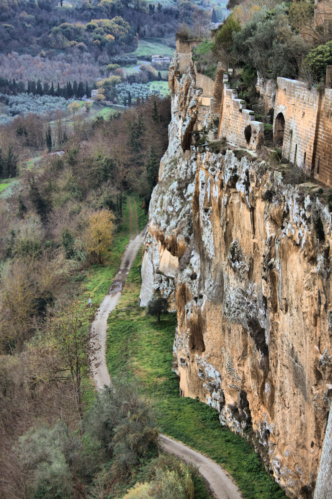
The town of Orvieto can answer very many kinds of interests: art, culture, food, ancient history, and even – Nature and sport! All these issues are linked and connected by the very structure of the town as it has been shaped during the centuries, rising on top of its tuff cliff (called la Rupe).The highest point in the Cliff is 325 meters(almost 1,000 feet) on sea level; as if it were charged with atavistic fierceness, it dominates a valley encircled by sweet hills, a typical element of Umbrian landscape. Preciselyall around the Cliff you may enjoy a tour among Nature, where many of the above-mentioned aspects are gathered.The hiking route(N.B. Hiking is usually termed “trekking” in Italy), called Anello della Rupe, “Cliff Ring,” follows the perimeter of the town, defended by its natural walls. The route will take place inside the PAAO, the Archaeological and Natural Park of the Orvieto Area.
The Features of the Route
The hiking route, as its name suggests, is shaped like a ring. It is therefore possible to choose any starting point, and have it as the finish line too. Some people like to start from downtown, more precisely the Albornoz Fortress, and leave it through the gate called Porta Rocca, or the one called Porta Soliana. Other people start from the parking lots, just off the old town, at the foot of the Cliff. Both choices can be adapted to one's daily plan for the discovering – or rediscovering – of Orvieto. It is anyway not a hard route, as also certified by the CAI parameters mostly followed in Italy. The route, supplied with clear signage, is some 4.5 kilometers long, less than three miles. Differences in height are light; the trail is on beaten earth, paved, with no slippery tracts.
Where Nature Meets History
Inside and Outside Yourself
The Cliff Ring is surrounded by Nature, with plenty of the typical trees of this area – they will sometimes thin out, and show the Orvieto countryside, the valley, the scenic landscapes not hidden by the interposed hills. The route is also rich in archaeological and historical sites. Here Nature merges with Culture. Together, they can arouse a true passion for this territory: the green embraces your quiet stroll, history teases the hourglass of time, and your glimpses on the landscape provide the best way to make your thoughts take off, so as to feel completely absorbed by the beauty of Nature – “who” always walks with us, and about “whom” we too often forget. Once in a while, it is worth rediscovering ourselves; this hiking route allows us an inner journey by admiring that which lies outside ourselves.
Historical Sites along the Path
Wherever you may choose to start, it will anyway be possible to see many cultural treasures. After passing Porta Rocca (see above), you will bump upon the ruins of a little rock church dedicated to the Madonna della Rosa (Our Lady of the Rose). The church kept a picture of Virgin Mary much worshiped by the inhabitants, who on a special day every year arranged a solemn procession toward the cathedral. However, after some boulders had fallen and destroyed the church in the 17th century, the place got more and more forlorn.
According to a legend, here is where they found the dead body of Pietro Parenzo. He had been the first podestà (Medieval mayor) of Orvieto, sent by the Pope in the late 12th century to pacify the clashes between Guelphs and Ghibellines. Killed by the Cathars (a radical religious movement), Parenzo was then honored as a saint by the Catholic Church, to the extent that Luca Signorelli portrayed him in the Chapel of Saint Brizio, inside the Cathedral.
Another interesting site along the hiking route is the Grotto of Fossilized Tree Trunks: a cavern where to see vegetable fossils dating back to 350 thousand years ago, much before the Cliff had been geologically shaped!
Walking onward, you will reach the archaeological area of Cannicella, with an Etruscan necropolis and a later shrine (it can only be visited on request). Some steps more, and the path will open onto the valley, where your attention will be caught by a solitary abbey in the midst of the green land. It is Saint Severus and Saint Martyrius' Abbey, an old Benedictine monastery, now a private property.
Then, a wall starts to skirt the path: the remains of the Medieval aqueduct, that will be accompanying you for only a brief tract. After passing by Porta Maggiore (the Great Gate), that was the oldest town entrance, you will keep walking up to the Necropolis at Crocifisso del Tufo (Tuff Crucifix), and the little church after which the whole archaeological site is named.
The “Cliff Ring” Hiking Route: Recap
- Route shape: a true ring
- Difficulty level: T (CAI parameters) = easy
- Time needed: some 2 hours
- Route length: 4.5 kilometers (2.8 miles)
- Difference in height: light
- Signage: yes
- Feasible in every season
- On foot or by mountain bike
- Features: the route will let you fully admire the town's architecture, enjoy taking photos, have some time for yourself, and be enchanted by all those shades of green.
INFORMAZIONI
Località
Piazza Cahen, 5B, 05018 Orvieto TR
Orari
Giugno-Agosto: tutti i giorni 9:00-20:00
1-22 Settembre: tutti i giorni 9:00-19:00
5-11 Ottobre: tutti i giorni 9:00-19:00
12-19 Ottobre chiuso per lavori di manutenzione.
Dal 20 ottobre: tutti i giorni dalle 9:00-19:00
La biglietteria chiude 45 minuti prima dell’orario di chiusura.
Contatti
Email: info@genesiagency.it


